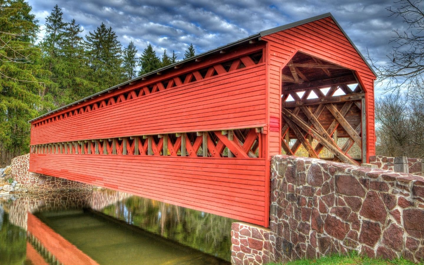
Have you ever wondered why covered bridges appeal to so many people? Namely, their history and charming location. To tour old and charming covered bridges, Pennsylvania is the place to go. Pennsylvania boasts the most of any state in the US. And you’ll find many in beautiful Lancaster County, well-known as Amish country, making it the perfect place for a scenic driving tour. Here is your guide to Lancaster County Covered Bridges - all you need to know.
History of Covered Bridges
Old bridges were once commonly made with wood trusses. When left open, the bridges would be exposed to sun, heat, rain, snow and cold, causing them to deteriorate within about 20 years. However, a covered bridge, one that was protected from the elements, could last up to 100 years. At one time, estimates indicate that the US had about 12,000-14,000 covered bridges. These mostly single-lane bridges were mostly built between 1825 - 1875, usually to span rivers and streams. Their natural longevity when combined with proper maintenance, means they can last a long time. So visiting covered bridges today is like taking a step, or drive, back in time.
The mid-1800s arrived with the development of wrought iron and cast iron which were cheaper and longer lasting. Building bridges with metal materials meant that overhead protection from the elements was no longer needed. Combined with the fact that most covered bridges were single-lane with low width and height clearances, covered bridges gradually became obsolete. Today, there are only about 750-1,000 covered bridges left in the United States. Pennsylvania has the most with 219 covered bridges, about 150 of which still are in use.
Charming Location & Appeal
The second reason covered bridges appeal to so many people is their location. Many are located in a country setting, often full of grist mills, winding brooks, and old pastoral churches. This charming and old-fashioned setting draws people into a world that once was, evoking feelings of nostalgia for a simpler time. Lancaster County is just the setting as its home to many Pennsylvania Dutch, a simple and religious people who continue to live a more simple life.
We hope you enjoy this driving tour of covered bridges in Lancaster County. Plan an overnight stay at our nearby Inn at Westwynd Farm for a restful midweek or weekend getaway.
Beginning at Westwynd Farm, head southeast on PA-283
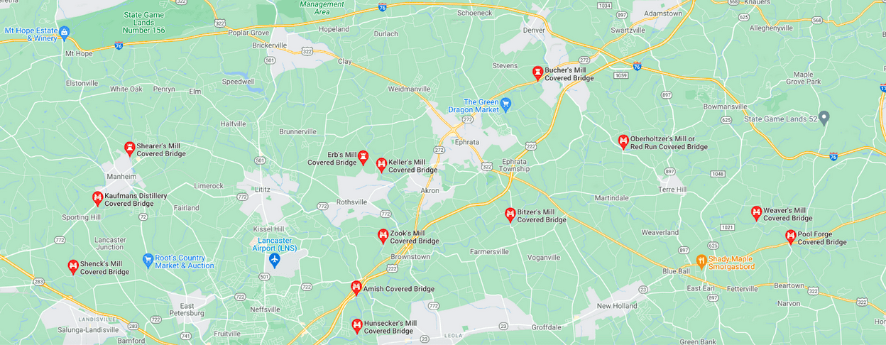
NORTHERN LANCASTER COUNTY COVERED BRIDGES
North of PA-283 and Highway 340
Discoverlancaster.com + scooter tours
Shenck's Mill Covered Bridge
Also know as Schenk’s Mill Covered Bridge
Official Designation: Big Chiques #4 Bridge
Location: Chiques Creek, Manheim, PA 17545
Specs
- Spans: Big Chiques Creek (known as Chickies Creek prior to 2002)
- Color: Red, inside and outside (both approaches are painted traditional white)
- Dimension: 96’ (L) x 15’ (W)
- Built: By Charles Malhorn and Levi Fink in 1847 - rebuilt in 1855.
- Design: Single span, double Burr arch truss
Official Designation: Big Chicques #1 Bridge
Location: 661 W Sun Hill Rd, Manheim, PA 17545
Specs
- Spans: Big Chiques Creek
- Color: Red, inside and outside (both approaches are painted traditional white)
- Dimension: 96’ (L) x 15’ (W)
- Built: By James C. Carpenter in 1857; rebuilt in 1874
- Design: Single span, double Burr arch truss
Shearer's Mill Covered Bridge
Official Designation:
Location: 504 E Adele Ave, Manheim, PA 17545
Specs
- Fun Fact: Only covered bridge in Lancaster County painted entirely in red.
- Spans: Big Chiques Creek
- Color: Red
- Dimension: 86’ (L) x 15’ (W)
- Built: By Jacob Clare in 1847; rebuilt in 1855; moved in 1971 to present location.
- Design: Single span, double Burr arch truss
Erb's Mill Covered Bridge
Official Designation: Hammer Creek #1 Bridge
Location: Erb's Bridge Rd N of Picnic Woods Rd, about 1 mile N of PA route 772 and Rothsville.
Specs
- Spans: Hammer Creek
- Color: Red, inside and outside (both approaches are painted traditional white)
- Dimensions: 80’ (L) x 15’ (W)
- Built: In 1849 on Erb family land; rebuilt in 1887 by John G. Bowman
- Design: Single span, double Burr arch truss
Keller's Mill Covered Bridge
Also known as: Guy Bard or Rettew’s Covered Bridge
Location: 103 Middle Creek Rd, Lititz, PA 17543 (formerly on Rettew Mill Road)
Official Designation: Cocalico No. 5 Bridge
Original Specs
- Spans: Spans Cocalico Creek
- Color: White
- Dimensions: 74’ (L) x 15’ (W)
- Built: By Elias McMellen in 1873; rebuilt in 1891by McMellen; disassembled and moved to present location in 2006; reconstructed in 2009.
- Design: Single span, double Burr arch truss
Current Specs
- Color: White, outside only (only all-white bridge in Lancaster County)
- Dimensions: 74’ (L) x 16’ (W)
Zook's Mill Covered Bridge
Also known as: Wenger or Rose Hill Covered Bridge
Official Designation: Cocalico #7 Bridge
Location: west of Brownstown on T 797, near Warwick and West Earl Townships
Specs
- Fun Fact: Featured in the 1978 movie, The Boys from Brazil.
- Spans: Cocalico Creek
- Color: Red, inside and outside (both approaches are painted red with white trim)
- Dimensions: 89’ (L) x 15’ (W)
- Built: By Henry Zook in 1849; rebuilt in
- Design: Single span, double Burr arch truss
Hunsecker’s Mill Covered Bridge
Location: On Hunsecker Rd - about 1 mile SE of PA Route 272, and 0.5 miles N of PA Route 23 off Mondale Rd
Specs
- Fun Facts: Longest single span covered bridge in Lancaster County. Also, this bridge may be the only one in Lancaster County with horizontal floor boards, which make for a bumpy crossing.
- Spans: Conestoga River
- Color: Red
- Dimensions: 180’ (L) x (W)
- Built: By John Russell in 1843; rebuilt several times, most recently in 1973.
- Design: Single span, double Burr arch truss
Bitzer's Mill Covered Bridge
Also known as: Martin’s Mill Bridge, Cider Mill Covered Bridge, and Fiand’s (or Fiantz’s) Covered Bridge
Official Designation: Big Conestoga #2 Bridge
Location: Cider Mill Rd. in Lancaster (from US Route 322 on Cabin Dr, head south for 1.5 miles (turns into Conestoga Creek Rd). Take a left onto Cider Mill Road.
Specs
- Fun Fact: Oldest bridge in Lancaster County that is still in use.
- Spans: Conestoga River
- Color: Red, outside only (both approaches are painted traditional white)
- Dimensions: (L) x (W)
- Built: By George Fink and Sam Reamsnyder in 1846
- Design: Single span, double Burr arch truss
Pool Forge Covered Bridge
Location: 40°7′46.8″N 75°58′36.6″W (40.12967, -75.97683)
Specs
- Spans: Conestoga River
- Color: Red, outside only (both approaches are painted red)
- Dimensions: 99’ (L) x 15’ (W)
- Built: By Levi Fink and Elias McMellen in 1859; rebuilt in
- Design: Single span, double Burr arch truss
Weaver's Mill Covered Bridge
Also known as: Isaac Shearer’s Mill Bridge
Location: Coordinates 40.1412°N 75.9978°W
Specs
- Spans: Conestoga River
- Color: Red, inside and out (both approaches are traditional white)
- Dimensions: 85’ (L) x 15’ (W)
- Built: By B. C. Carter and J. F. Stauffer in 1878; rebuilt in
- Design: Single span, double Burr arch truss
Oberholtzer's Mill
Also known as: Red Run Covered Bridge
Location: Red Run Campground (private property)
Specs
- Fun Fact: Could be called the “Covered Bridge to Nowhere” because it’s landlocked. The Muddy creek waters were diverted around the bridge so no water currently flows underneath.
- Spans: Formerly Muddy Creek
- Color: Red, inside and out (both approaches are traditional white)
- Dimensions: 107’ (L) x 15’ (W)
- Built: By Elias McMellen in 1866; rebuilt in
- Design: Single span, double Burr arch truss
Bucher’s Mill Covered Bridge
Also known as: Butcher’s Mill Covered Bridge
Official Designation: Cocalico #2 Bridge
Location: Coordinates 40°12′29″N 76°8′5″W
Specs
- Fun Fact: Second shortest bridge in Lancaster County (Landis Mill is the shortest)
- Spans: Cocalico Creek
- Color: Red, inside and out (both approaches are traditional white)
- Dimensions: 64' (L) x 15' (W)
- Built: By Elias McMellen in 1891; rebuilt by McMellen in 1892
- Design: Single span, double Burr arch truss
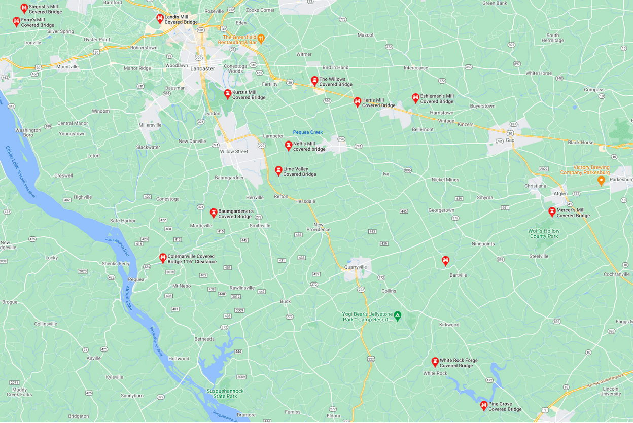
SOUTHERN LANCASTER COUNTY COVERED BRIDGES
South of PA-283 and Highway 340
Siegrist's Mill Covered Bridge
Official Designation: Big Chiques #6 Bridge
Location:
Specs
- Fun Fact: Named after the Siegrist family who lived nearby. Survived Hurricane Agnes in 1972, but was swept downstream during flooding from Tropical Storm Lee in 2011.
- Spans: Chiques Creek
- Color: Red, inside and out (both approaches are traditional white)
- Dimensions: 88' (L) x 15' (W)
- Built: By James C. Carpenter in 1885; closed in 2011, repaired, and reopened in 2013
- Design: Single span, double Burr arch truss
Forry's Mill Covered Bridge
Official Designation: Big Chiques #7 Bridge
Location: Coordinates 40.06646°N 76.4781°W
Specs
- Spans: Chiques Creek
- Color: Red, inside and out (both approaches are traditional white)
- Dimensions: 103' (L) x 15' (W)
- Built: By Elias McMellen in 1869; rebuilt in 1925
- Design: Single span, double Burr arch truss
Landis Mill Covered Bridge
Official Designation: Little Conestoga #1 Bridge
Location: Coordinates 40.0680°N 76.3448°W
Specs
- Fun Fact: Shortest covered bridge in Lancaster County.
- Spans: Little Conestoga Creek
- Color: Red, inside and out (both approaches are red with white trim)
- Dimensions: 53' (L) x (W)
- Built: By Elias McMellen in 1873; rebuilt in
- Design: Single span, double pyramidal-shaped Burr-type truss, multiple king post truss
Kurtz’s Mill Covered Bridge
Also know as: County Park Covered Bridge, Baer's Mill Covered Bridge, Isaac Baer's Mill Bridge, Keystone Mill Covered Bridge, Binder Tongue Carrier Covered Bridge, and Mill 2A Covered Bridge
Location: Coordinates 40.0135°N 76.2833°W
Specs
- Spans: Mill Creek
- Color: Red, inside and out (both approaches are red with white trim)
- Dimensions: 94' (L) x 15' (W)
- Built: By W. W. Upp in 1876; destroyed in flood in 1972; moved and repaired by David Esh in 1975
- Design: Single span, double Burr arch truss
Neff’s Mill Covered Bridge
Also known as: Bowman's Mill Covered Bridge
Official Designation: Pequea #7 Bridge
Location: Coordinates 39.9788°N 76.2258°W
Specs
- Spans: Pequea Creek
- Color: Red, inside and out (both approaches are traditional white)
- Dimensions: 102' (L) x (W)
- Built: By Christian Brackbill in 1824; rehabilitated in 2018
- Design: Single span, double Burr arch truss
Lime Valley Covered Bridge
Also known as: Strasburg Bridge
Official Designation: Pequea #8 Bridge
Location: Coordinates 39.9607°N 76.2350°W
Specs
- Spans: Pequea Creek
- Color: Red, inside and out (both approaches are traditional white)
- Dimensions: 103' (L) x 15' (W)
- Built: By Joseph Cramer or Elias McMellen in 1871
- Design: Single span, double Burr arch truss
Baumgardener’s Covered Bridge
Official Designation: Pequea #10 Bridge
Location: Coordinates 39°55′50″N 76°17′42″W
Specs
- Spans: Pequea Creek
- Color: Red, inside and out (both approaches are traditional white)
- Dimensions: 120' (L) x 14' (W)
- Built: By Davis Kitch in 1860; rebuilt in 1987
- Design: Single span, double Burr arch truss
Colemanville Covered Bridge
Official Designation: Pequea #12 Bridge
Location: Coordinates 39°53′56″N 76°20′32″W
Specs
- Fun Fact: Second-longest single-span covered bridge still being used (after Hunsecker's Mill Covered Bridge)
- Spans: Pequea Creek
- Color: Red, inside and out (both approaches are red with white trim)
- Dimensions: 170' (L) x 15' (W)
- Built: By James C. Carpenter in 1856; partially rebuilt in 1938 by Edmund Gardner; partially rebuilt by David Esh in 1973; completely rebuilt by Lancaster County in 1992 (raised 6' and moved west a few feet)
- Design: Single span, double Burr arch truss
White Rock Forge Covered Bridge
Official Designation: West Octoraro #2 Bridge
Location: Coordinates 39.8247°N 76.0900°W
Specs
- Spans: West Branch of Octoraro Creek
- Color: Red, inside and out (both approaches are traditional white)
- Dimensions: 103' (L) x 13' (W)
- Built: By John Russell and Elias McMellenin 1847; rebuilt in 1884
- Design: Single span, double Burr arch truss
Pine Grove Covered Bridge
Location: Coordinates 39°47′37″N 76°02′41″W
Specs
- Fun Fact: Longest covered bridge in Lancaster County. Only two-span covered bridge still in use.
- Spans: East Branch of Octoraro Creek
- Color: Red outside only (both approaches are traditional white)
- Dimensions: 195' (L) x 15' (W)
- Built: By Elias McMellen in 1884
- Design: Two span, double Burr arch truss
Jackson’s Sawmill Covered Bridge
Also know as: Eichelberger's Covered Bridge
Official Designation: West Octoraro #1 Bridge
Location: Coordinates 39.8970°N 76.0800°W
Specs
- Fun Fact: Only covered bridge in Lancaster County not built perpendicular to the stream it crosses due to the sawmill on one side and rock formations on the other.
- Spans: West Branch of Octoraro Creek
- Color: Red, inside and out (both approaches are traditional white)
- Dimensions: 139' (L) x 15' (W)
- Built: By John Smith and Samuel Stauffer in 1878 ; rebuilt in 1985
- Design: Single span, double Burr arch truss
Mercer’s Mill Covered Bridge
Also know as: Mercer's Ford Covered Bridge
Official Designation: East Octcoraro #2 Bridge
Location: Coordinates 39.9315°N 75.9815°W
Specs
- Spans: East branch of Octoraro Creek
- Color: Red, inside and out (both approaches are traditional white)
- Dimensions: 80' (L) x 15'-4" (W)
- Built: By B. J. Carter in 1880
- Design: Single span, double Burr arch truss
Leaman's Place Covered Bridge
Also known as: Eshleman's Mill Covered Bridge
Official Designation: Pequea #4 Bridge
Location: Coordinates 40.0120°N 76.1078°W
Specs
- Spans: Pequea Creek
- Color: Red, inside and out (both approaches are traditional white)
- Dimensions: 113' (L) x 15' (W)
- Built: By James C. Carpenter in 1845; rebuilt by Elias McMellan in 1893; rehabilitated in 2004
- Design: Single span, double Burr arch truss
Willow Hill Covered Bridge
Location: Coordinates 40.0250°N 76.2033°W
Specs
- Fun Fact: Foot traffic only. Built with parts of the Miller's Farm Covered Bridge (built in 1871 by Elias McMellen) and the Good's Fording Covered Bridge (built in 1855)
- Spans: Miller's Run
- Color: Red outside only (both approaches are traditional white)
- Dimensions: 93' (L) x 15' (W)
- Built: By Roy Zimmerman in 1962; rebuilt in
- Design: Single span, double Burr arch truss